Three Notched Trail Route Options - Thoughts

At last! Route options for the Three Notched Trail are out now for public feedback. I've had a few days to mull on them since the public meeting where they were presented. You can view the maps in the wacky virtual room space here: https://app.seekbeak.com/v/AQjQxwZ7zkD
But if you just want to see the PDFs, I'll also link those as I go through the route segments.
Overall - I don't think there's any truly bad options here. The main question in my mind: is this trail meant more for scenic recreation, or meant to get commuters and customers out of cars?
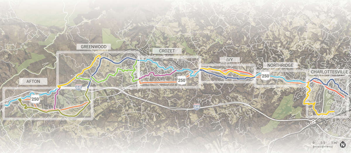
From west to east, we start with Afton.
Afton
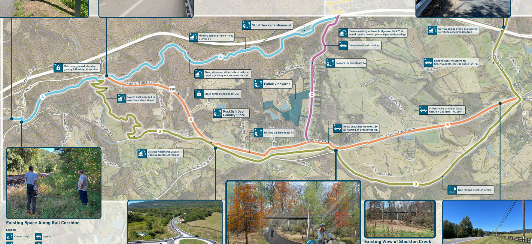
To me, this segment - starting from the Blue Ridge Tunnel, winding out down the mountain towards Crozet - is best-suited to prioritizing scenic routes. I don't expect commuters from Waynesboro will be using the Blue Ridge Tunnel as a commuting route.
I personally tend to like route D here - switchbacks down from the tunnel, then along a wide, meandering route following Stockton Creek before bending north to the Greenwood segment. But I think the one I'd actually rank most highly here is the Route C --> Route B option, incorporating as much of Bike Route 76 as possible. It's embarrassing that Route 76 is as dangerous as it is in Albemarle County; the chance to make it a protected shared-use path is nothing to sneeze at.
Greenwood
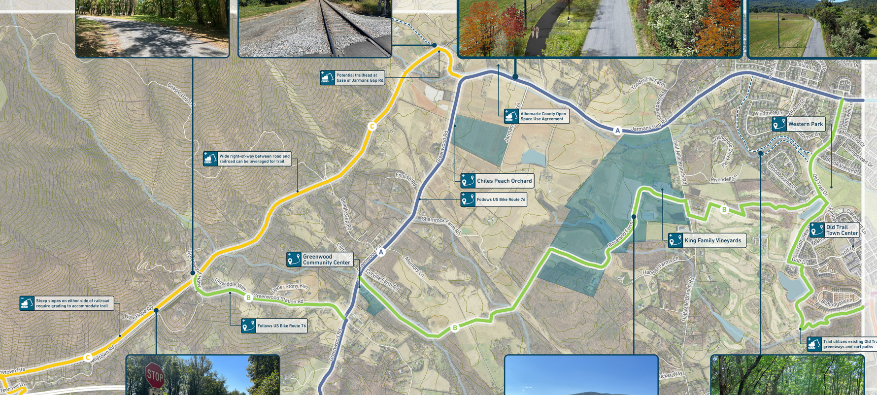
I'd like to get as much of Bike Route 76 in the trail as possible, so option A is attractive here. But I think option B has my heart, even considering bike route 76. I'm very into the idea of having this trail run through at least one town center in Crozet - either Old Trail Town Center or the Downtown Crozet Square. Beyond the whole "connecting customers to businesses" piece of the equation, it would be a big win for everyone in Crozet to put major multimodal transportation options right in the heart of population density in Crozet.
Crozet
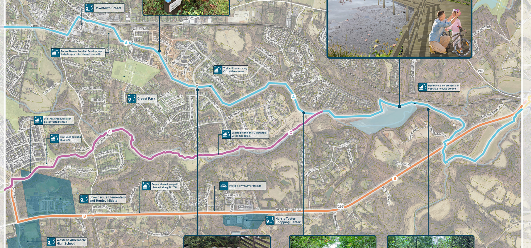
Hey, there's my stomping ground.
At first, I was really drawn to route A, passing right through downtown Crozet. Having a regional shared-use path run right through the actual heart of Crozet sounds like a great idea.
But the more I've thought about it, the more I like route B - the orange route on this map, following route 250 all the way. I think this makes the Three Notched Trail much more viable as a commuting route - an alternative for students at Henley and Western, a straight shot towards Charlottesville for folks getting into the city.
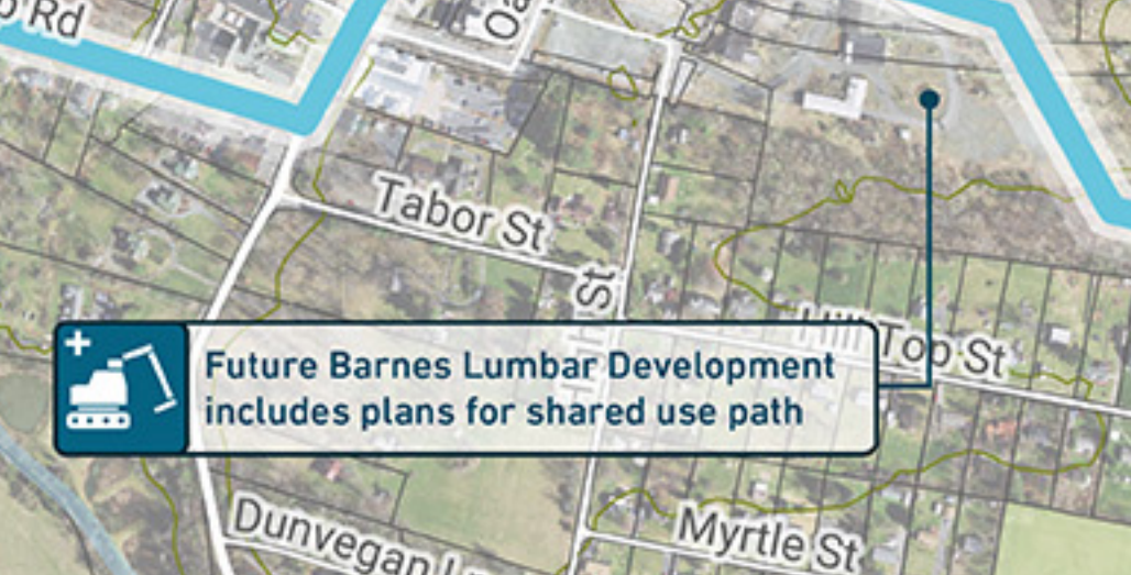
I would have loved to use this trail as an opportunity to get all the Crozet connections we've been dreaming of - a shared-use path on Three Notch'd Road/240, then down Crozet Ave to 250, for example. But there's a lot to like about all the route options here. As much as I think I'd rather see this as a commuting segment, the idea of a scenic ride along the shore of the Lickinghole basin is definitively appealing. And like I said, it makes sense to try and put this right through the Barnes Lumber development site.
Or rather, the Barnes Lumbar site...
Ivy
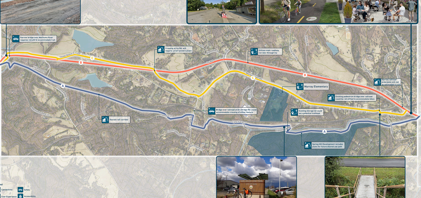
From here, I tend to like route A, the blue line to the south of the map. It has a few more doglegs than the other routes, but I like the possibility for a trailhead...and I like that it provides a shared-use path connection for the future homes at Spring Hill Farms, which otherwise will be just as stranded as any other subdivision in the rural area.
With that said, I do see a lot of value in following 250 - route B, the orange route. And whatever happens with this segment, I'd love to see this as a way to reinvigorate the Toddsbury of Ivy site and draw people towards the new storefronts over there near the post office. That whole area would be a great stop on a regional shared-use trail.
Northridge
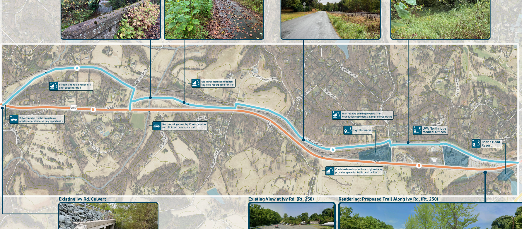
Penultimate segment! Only two route options presented here - route B, in orange, following 250, or route A, in blue, along older routes. I'd combine them, personally - follow 250 east out of Ivy, then north on West Leigh Drive, then following route A the rest of the way into Charlottesville. This seems like a place where it's worth it to me to follow existing trail foundation easements.
Charlottesville
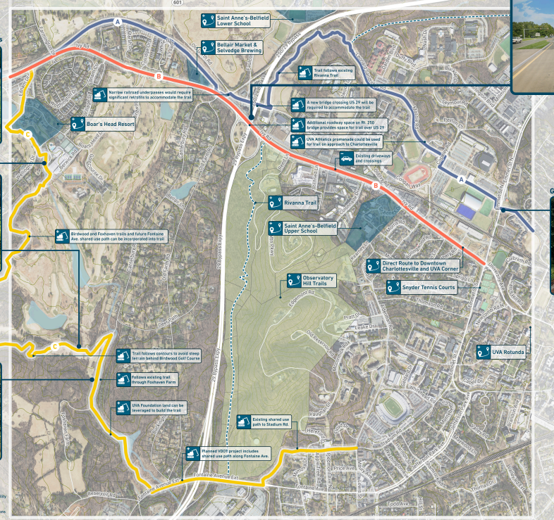
This is maybe the most critical set of decisions in determining the future value of this trail as a commuting route. Basically:
Route A - north along the railroad tracks, under the bypass, then skirting the edge of the large new housing development before eventually chasing Massie to Copley, down across the pedestrian bridge, and terminating over by Lambeth field.
Route B - follows 250, no questions asked. Terminates at the Emmett/Ivy intersection.
Route C - a wild series of meandering doglegs south along Boar's Head and various golf course parcels and trails, eventually finding civilization at Fontaine extended and meandering over to terminate at Stadium and Alderman.
Of the three, I want to see route C the least. I think it would undermine any effort to make this a commuter-friendly route; it appears to be almost 4 miles long, where route A is just over 3 miles and route B is ~2.75 miles.
Route A would probably be my preference, if only because it will serve the Old Ivy Residences development - a development that otherwise has relatively few options for non-car transportation, despite close proximity to the city. But it's hard to argue with Route B - the most direct, straightforward path into Charlottesville.
Final Ruminations
I like what they've done with these routes so far. There's a few weaker options, but no bad ones, and I'd be glad to see any of them realized. It might take a decade, but we're getting there - bit by bit.
Leave your feedback, if you haven't already! We have until the end of January. https://engage.albemarle.org/three-notched-trail-master-plan/surveys/phase2